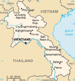
Laos
Dong Amphan Protected Area
mountainous. Access is mainly limited to dry season only. The lowland evergreen, semi-evergreen, is mixed with deciduous and dry dipterocarp forests. Coniferous and broadleaf woodland,…
Tham Nang Aen Cave
Tham Nang Aen Cave is located 18km northeast of Thakhaek on Route 12. To get into this cave, you need to turn right at the…
Muang Sing Exhibition
Situated close to the center of town, the Muang Sing Exhibition is a good place to start exploring Muang Sing\’s rich culture and history. The…
Wat Saen
Along the main Sisavong Vang Road between the main commercial district and Wat Xieng Thong are a string of smaller temples. The largest and most…
Mekong Riverfront
Vientiane is sited right on the Mekong River, and the riverfront area of town is a nice place to spend an evening, along with everyone…
LAOS GEOGRAPHY
LAOS GEOGRAPHY Laos, a landlocked nation that covers 236,800 square kilometers in the center of the Southeast Asian peninsula, is surrounded by Burma, Cambodia,…
LAOS TRADITIONAL HANDICRAFTS
LAOS TRADITIONAL HANDICRAFTS THE OVERVIEW OF LAOS HENDICARFT The Lao crafts emerged primarily as an expression of the ritual or functional needs of rural society,…
Pak Tha Village
This medium sized village is set at the confluence of the Mekong and Nam Tha rivers and is a comfortable place to break the journey…
Tham Pha Nya In Cave
The Tham Pha Nya In Cave is located 17km northeast of Thakhaek on Route 12. There is no sign, but turn left through a blue…
That Xieng Tung
That Xieng Tung is the most important religious monument in Muang Sing. It is believed locally that the stupa contains the Adam\’s-apple of the Lord…
Wat Visoun and That Makmo
The very old temple of Wat Visoun, also called Wat Wisunalat is built on the south side of Phou Si hill, outside of the main…
Nam Ngun Lake
Located 90km north of Vientiane municipality is the Nam Ngum reservoir, a huge artificial lake created as part of a hydroelectric scheme. The lake is…

